Agency: Instituto Geográfico Nacional (IGN)
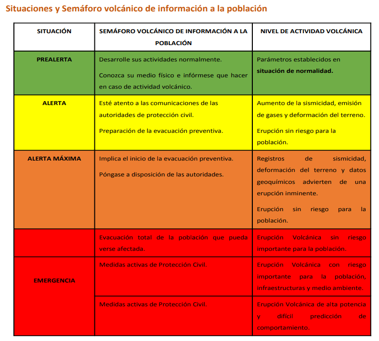
Name: Semáforo Volcánico [Volcanic Traffic Light]
Elements of VAL system
| Domain | Terrestrial or All |
| Volcano | All |
| Scheme range | 4-level scale |
| Lowest level | 1 |
| Highest level | 4 |
| Level name type | Word |
| Level for lack/loss of monitoring | No |
| Volcanic activity | Yes |
| Hazards possible | No |
| Locations affected | No |
| Potential impacts | Yes |
| Forecast language | Yes |
| Timing language | Yes |
| Actions to take | Yes |
| Agency actions | No |
| Link to evacuations | Yes |
| Reporting frequency per level | No |
| Link to monitoring thresholds | No |
| Step-up and step-down language | No |
VAL sources and links
The images below are static examples of VAL information pages and DO NOT represent current alert levels. While we strive to maintain the links below, they may not always work. For the current alert level, please consult the proper institutional authorities.
Volcano Page (Hierro)

Volcano Page (La Palma)

Volcano Page (Tenerife)

Social Media (INVOLCAN)

Social Media (IGN)
Related References
Dirección General De Seguridad Y Emergencias. (2018). Plan Especial De Protección Civil Y Atención De Emergencias Por Riesgo Volcánico En La Comunidad Autónoma De Canarias PEVOLCA. Boletín Oficial de Canarias núm. 154. https://involcan.org/wp-content/uploads/2018/10/boc-a-2018-154-3785.pdf