Agency: Icelandic Meteorological Office (IMO)
Name: Volcanic Alert Level
Note: Terrestrial alert levels are issued on the hazard maps themselves, for example, this map from Iceland Meteorlogical Office (IMO), 2025.
The aviation VAL system can be found here, and follows the standard ICAO aviation VAL system.
Elements of VAL system
| Domain | Terrestrial |
| Volcano | All |
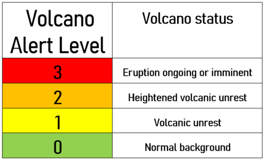
| System range | 0–3 level scale |
| Lowest level | 0 |
| Highest level | 3 |
| Level name type | Number |
| Level for lack/loss of monitoring | No |
| Volcanic activity | Yes |
| Hazards possible | No |
| Locations affected | No |
| Potential impacts | No |
| Forecast language | Yes |
| Timing language | Yes |
| Actions to take | No |
| Agency actions | No |
| Link to evacuations | No |
| Reporting frequency per level | No |
| Link to monitoring thresholds | No |
| Step-up and step-down language | No |
VAL sources and links
The images below are static examples of VAL information pages and DO NOT represent current alert levels. While we strive to maintain the links below, they may not always work. For the current alert level, please consult the proper institutional authorities.
Hazard Map

Social Media

Related References
Icelandic Met Office. (2025). The Volcano Alert Level System (VALS). https://en.vedur.is/earthquakes-and-volcanism/volcanoes/volcano-alert-level-system/
Icelandic Met Office. (2025). New hazard map covering a larger area. 15 April 2025. https://en.vedur.is/about-imo/news/uplift-continues-beneath-svartsengi